
Deepwater Group furthers orange roughy research
4 November 2021
Deepwater fisheries quota owners have committed to a five-year scientific research and monitoring programme.
In partnership with Australia’s Commonwealth Scientific and Industrial Research Organisation (CSIRO), the programme aims to assess the biomass of selected deepwater fish stocks and to monitor and quantify fisheries interactions with deepwater benthic communities.
CSIRO and deepwater quota owners have collaborated over the past 22 years to research, develop and deploy science to better inform sustainable deepwater fisheries practices.
“Working together over these years has successfully combined the best available scientific research and fishing capabilities to develop and apply new acoustic techniques to survey orange roughy stock sizes in particular,” Deepwater Group chief executive George Clements says.
“Since 1998, quota owners have directly invested $17 million into scientific research on orange roughy, delivering 37 biomass surveys and 11 stock assessments, in addition to those contracted by Government. This research work was in addition to the $27 million of science invested in orange roughy as purchased by Fisheries New Zealand and funded by quota owners through cost recovery levies during this period.
“Without this additional directly purchased science work, the management of New Zealand’s orange roughy fisheries would not be so well-grounded scientifically and we would not have been able to gain accreditation for sustainably caught seafood under the Marine Stewardship Council (MSC) international guidelines. Our three main orange roughy fisheries, which together produce 82 percent of New Zealand’s annual catch, are now accredited under the MSC programme.”
This new 5-year programme involves a further $11 million co-investment in scientific research through the further application of CSIRO’s world-leading technologies and scientific expertise, complemented by Deepwater Group shareholders’ knowledge, vessels, and fishing capabilities in deepwater fisheries, and aims to:
- further advance developments in multifrequency acoustic biomass surveys,
- undertake image-based surveys to quantify the benthic (seabed) biodiversity of selected areas
- develop a robust underwater camera system that can be routinely deployed on deepwater commercial trawls to monitor the seabed habitats used for fishing.
The first aim is the continued development of the science-industry survey methods that integrate multi-frequency acoustic and video optical systems on commercial trawl nets so that stock sizes of orange roughy and other deepwater fish species can be estimated with higher confidence. CSIRO’s world-leading capabilities have been routinely deployed in New Zealand and Australian waters since 1998, as well as in the Tasman Sea and the Indian Ocean. New and improved tools and technologies will be incorporated and implemented in the surveys at the core of our new 5-year programme.
The second aim is to quantitatively assess the make-up and distributions of deepwater benthic habitats and biodiversity within each survey area, including the prominent epi-benthic species1 and the biogenic habitats2 formed by corals. These benthic habitat surveys will be undertaken on board industry vessels using CSIRO’s underwater towed video system with real-time connectivity to the survey vessel. Surveys will initially be on selected Underwater Topographical Features (i.e., underwater hills, knolls), on the Chatham Rise and on the Challenger Plateau. Over the 5-year period, the plan is to survey (or to re-survey) the benthic habitats of 20 to 25 of the key features that are subject to trawling.
“It is important to obtain factual information about the possible impacts of bottom trawling as this is a growing concern in New Zealand and globally, particularly regarding corals. While this is essential public good science and is, therefore, work that should be funded by the Government, as this scientific work is not being otherwise undertaken it falls upon the industry by default to collect it,” Clement says. “Industry believes anti-trawling proponents frequently overstate the impacts of bottom trawling for effect, labelling it ‘destructive’ without context or without adequate scientific information. Providing relevant scientific knowledge and hard data for orange roughy habitats is a key part of what we will obtain through this ongoing CSIRO-industry partnership.”
“The context here is important. All forms of food production necessitate some environmental change. On land, even organic farming requires a wholesale change to the pre-existing natural ecosystem. At sea, we do not have that option – we must ensure the natural ecosystem remains intact and fully functioning so that we can continue providing 700 million servings of sustainable, natural, and nutritious seafood from New Zealand’s deepwater fisheries every year.”
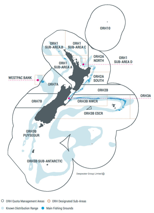
Orange roughy fisheries in the New Zealand EEZ. ORH 3B NWCR, ORH 3B ESCR, and ORH 7A are MSC-certified fisheries.
The Fisheries Act 1996 allows for impacts by commercial activities on non-fish species along with the obligation to ensure that these impacts are not adverse to their populations, including epi-benthic fauna - particularly species such as corals. The Act does not mean there can be no impacts, it means there must be no adverse effects on their populations overall.
“The challenge that we face is uncertainty about the overall effect because, while corals are widespread throughout New Zealand’s EEZ, the details of the locations of species are inadequately known. As a first step we need to collect data to establish this knowledge within our fishing grounds,” Clement says. “We can then assess any impacts that may be caused by trawling to establish if these are adverse effects or are likely to reduce the structure and function of the commonly encountered habitats to a point where there would be serious or irreversible harm.”
Survey information will be analysed by CSIRO, using their newly developed artificial intelligence (AI) capabilities to detect deep-sea epi-benthic species. This information will be overlaid with other data, such as trawl paths, to enable assessments of any impacts of trawling and of the extent of inaccessible areas untouched by trawling. Only small areas are bottom trawled in New Zealand’s EEZ each year, in total amounting to around 1%. Over 30% of the EEZ is closed to bottom trawling. The large un-trawled areas already serve as natural refuge areas for key epi-benthic species that may otherwise be vulnerable to bottom trawling.
The programme’s third aim is to develop bespoke and robust UW camera hardware and software that can be routinely deployed during commercial fishing tows to collect digital imagery of the seabed along trawl towpaths.
“Given concerns about bottom trawling and the limited information from deepwater fishing grounds, it falls to industry to unequivocally demonstrate the degree of impact we are having on benthic biodiversity within our trawl paths,” Clement says. “To do this we need to collect data during our routine bottom trawling activities and have these independently analysed by a credible international research agency so that the Government and the public can be reliably informed.
“We will routinely collect high-resolution photographic and video footage to identify and quantify the benthic habitat types and biodiversity on the seabed we trawl across, commencing with our orange roughy trawl grounds. As most of the areas of interest lie between 800 m and 1,400 m depths, where it is dark and the ambient pressures are 100 times greater than at the surface, we not only need high-resolution cameras and powerful lighting systems contained within a pressure-secure waterproof housing but equipment that is also robust enough to withstand deployment and retrieval aboard working fishing vessels in rough weather conditions.“
Under the programme, CSIRO and DWG will develop the Seafloor Monitoring Automated Recording of Trawls system (aka SMART-Cam) for routine deployment on trawl nets during commercial fishing activities, together with automated methods to analyse the photographic data using CSIRO’s AI capabilities. Initial development work will be focused on orange roughy fishing grounds on the Chatham Rise.
Once developed and proven, CSIRO will provide multiple fit-for-purpose underwater camera systems to vessel operators for deployment during commercial orange roughy fishing operations to routinely record information on benthic biodiversity along trawl pathways.
1 Epi-benthic species are sessile invertebrates, including corals and sponges, which extend above the seabed and may therefore be vulnerable to damage if contacted by bottom trawls
2 Biogenic habitats are the term given to those areas where notable abundances of epi-benthic species form structured habitats